Country Data Geodata Tutorial
We started Country Data Primer Tutorial‘s perusal of the …
great Open Licence data source concerning a country data “cow.txt” flat file with semicolon column separators, thanks to the heads up at this great link
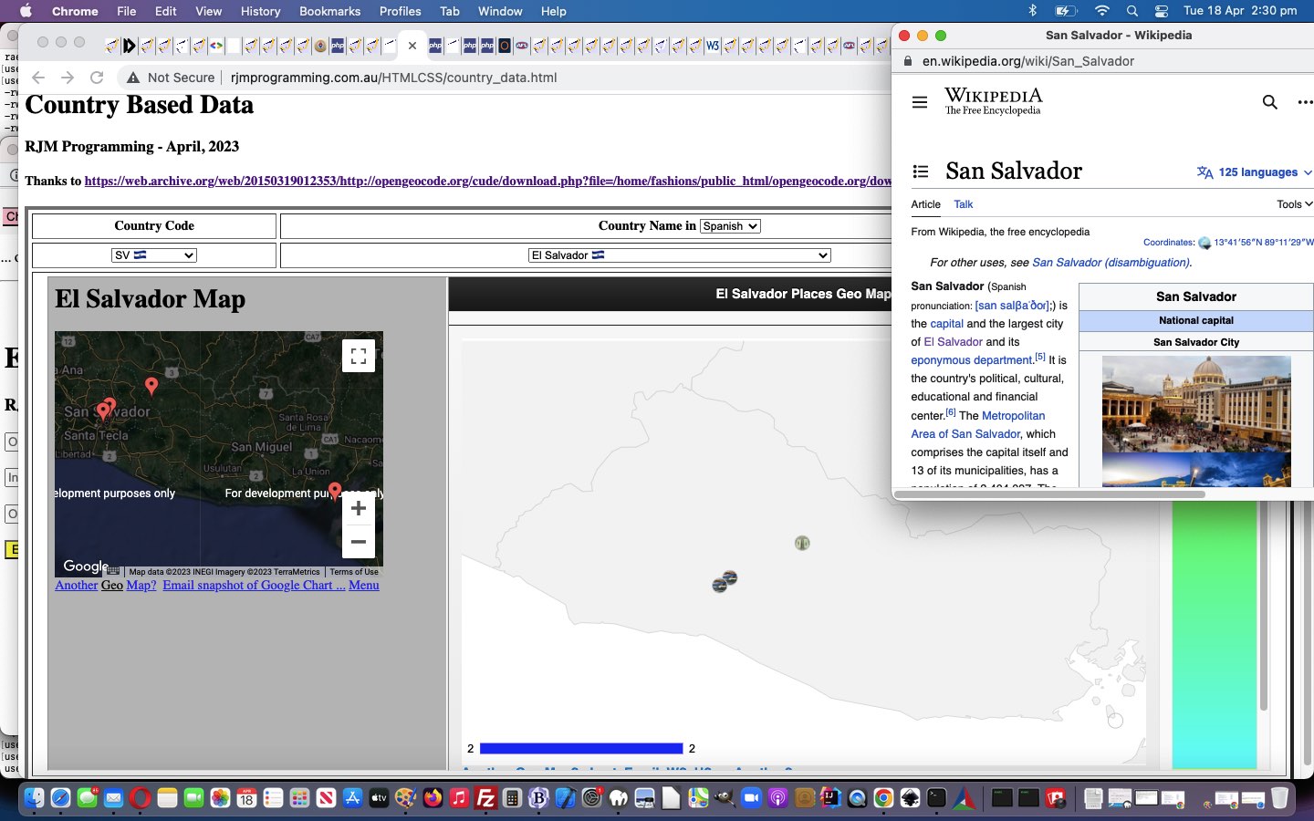
… start to our endeavours without referencing “geodata”. But there is “geodata” in “cow.txt”, and so it behoves us to represent that in a … in a … anyone, anyone? Yes, Anaximander, son of Praxiades … or is that Praximander, son of Anaxiades … please, in future, can you separate or one of you take the town drain home … we can plot positions on a map.
How about one of Google’s Charts, such as …
… so that the user can see “where” in the world the Country (and its Capital) are located?
Try this, in the changed country_data.html Country Data web application start below.
Previous relevant Country Data Primer Tutorial is shown below.
Country Data Primer Tutorial
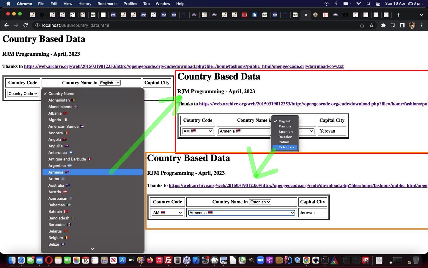
The other day we came upon a great Open Licence data source concerning a country data “cow.txt” flat file with semicolon column separators, thanks to the heads up at this great link.
With today’s blog posting we start out writing a Javascript and HTML web application using “cow.txt” hosted in an HTML iframe element arrangement, and relying on its “onload” event Javascript language …
  function checkif(iois, four) {

    var aconto = (iois.contentWindow || iois.contentDocument);

    if (aconto != null) {

       if (aconto.document) { aconto = aconto.document; }

       if (aconto.body != null) {

          if (origihcode == '') {

            origihcode=document.getElementById('ccode').innerHTML;

            origihname=document.getElementById('cname').innerHTML;

          } else {

            document.getElementById('ccode').innerHTML=origihcode;

            document.getElementById('cname').innerHTML=origihname;

         }

          var cols=[];

          var lines=aconto.body.innerText.split(String.fromCharCode(10));

          document.getElementById('tdcapital').innerHTML='';

          for (var i=0; i<lines.length; i++) {

            cols=lines[i].split(';');

            if (eval('' + lines[i].length) > 3 && eval('' + cols[0].length) == 2 && eval('' + cols.length) > eval('' + four)) {

              if (prevval != '' && prevval.indexOf(orflag(cols[0])) != -1) {

              var ihis='<option data-capital="' + cols[36].trim() + '"  data-capital4="' + cols[36].trim() + '"  data-capital8="' + cols[39].trim() + '"  data-capital15="' + cols[40].trim() + '"  data-capital17="' + cols[41].trim() + '"  data-capital32="' + cols[42].trim() + '"   data-capital29="' + cols[36].trim() + '" value="' + cols[0] + ' ' + orflag(cols[0]) +  '" selected>' + (cols[eval('' + four)].trim() == '' ? cols[4] : cols[eval('' + four)]) + ' ' + orflag(cols[0]) + '</option>';

              document.getElementById('cname').innerHTML+=ihis;

              document.getElementById('ccode').innerHTML+='<option data-capital="' + cols[36].trim() + '"  data-capital4="' + cols[36].trim() + '"  data-capital8="' + cols[39].trim() + '" data-capital15="' + cols[40].trim() + '"  data-capital17="' + cols[41].trim() + '"  data-capital32="' + cols[42].trim() + '"   data-capital29="' + cols[36].trim() + '"   value="' + (cols[eval('' + four)].trim() == '' ? cols[4] : cols[eval('' + four)]) + ' ' + orflag(cols[0]) +  '" selected>' + cols[0] + ' ' + orflag(cols[0])  + '</option>';

              document.getElementById('tdcapital').innerHTML=(('' + ihis.split(' data-capital' + document.getElementById('lang').value + '="')[1].split('"')[0].trim()) == '' ? ('' + ihis.split(' data-capital' + '="')[1].split('"')[0].trim())  : ('' + ihis.split(' data-capital' + document.getElementById('lang').value + '="')[1].split('"')[0].trim()) );

              } else {

              document.getElementById('cname').innerHTML+='<option data-capital="' + cols[36].trim() + '"  data-capital4="' + cols[36].trim() + '"  data-capital8="' + cols[39].trim() + '" data-capital15="' + cols[40].trim() + '"  data-capital17="' + cols[41].trim() + '"  data-capital32="' + cols[42].trim() + '"   data-capital29="' + cols[36].trim() + '"   value="' + cols[0] + ' ' + orflag(cols[0]) +  '">' + (cols[eval('' + four)].trim() == '' ? cols[4] : cols[eval('' + four)])  + ' ' + orflag(cols[0]) + '</option>';

              document.getElementById('ccode').innerHTML+='<option data-capital="' + cols[36].trim() + '"  data-capital4="' + cols[36].trim() + '"  data-capital8="' + cols[39].trim() + '" data-capital15="' + cols[40].trim() + '"  data-capital17="' + cols[41].trim() + '"  data-capital32="' + cols[42].trim() + '"   data-capital29="' + cols[36].trim() + '"   value="' + (cols[eval('' + four)].trim() == '' ? cols[4] : cols[eval('' + four)])  + ' ' + orflag(cols[0]) +  '">' + cols[0] + ' ' + orflag(cols[0])  + '</option>';

              }

           }

          }

       }

    }

    prevval='';

  }
… that dovetails with HTML …
<iframe style=display:none; id=myif onload=checkif(this,document.getElementById('lang').value); src='/cow.txt'></iframe>
… and imagine we’ll extend its functionality into the near future, onto its proof of concept country_data.html Country Data web application start …
We hope you hang about for the ride?!
If this was interesting you may be interested in this too.
If this was interesting you may be interested in this too.




The distinction between course-driven and immersion-driven learning is useful. A small extension to the australia.htm exercise would be a set of named map markers and a text filter: first update the visible markers on an input event, then add a collected/uncollected toggle, and finally persist only that toggle state in localStorage. That gives beginners a concrete reason to learn arrays, DOM updates and browser storage without needing PHP or MySQL first. It is also worth testing empty searches, a page reload and disabled storage separately; those are different failure cases. Disclosure: we maintain the GTA 6 interactive map. I am suggesting it as an example of a map-and-progress interface, not claiming that we used the tutorial code. Would you introduce persistence after the first working interaction, or keep the initial exercise entirely stateless?