Jammu and Kashmir
जम्मू और कश्मीर
جموں اور کشمیر |
| State of India |
|
|
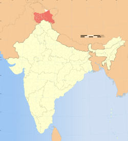
Location of Jammu and Kashmir in India |
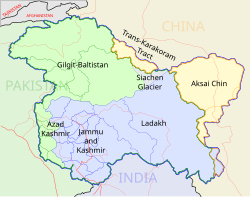
Map of Jammu and Kashmir |
| Coordinates (Srinagar): 33°27′N 76°14′E / 33.45°N 76.24°E / 33.45; 76.24Coordinates: 33°27′N 76°14′E / 33.45°N 76.24°E / 33.45; 76.24 |
| Country |
 India India |
| Region |
North India |
| Established |
26 October 1947 |
| Capital |
|
| Largest city |
Srinagar |
| Districts |
22 |
| Government[*] |
| • Body |
Government of Jammu and Kashmir |
| • Governor |
Narinder Nath Vohra |
| • Chief Minister |
Omar Abdullah |
| • Legislature |
Bicameral (89 + 36 seats) |
| • High Court |
Jammu and Kashmir High Court |
| Area |
| • Total |
222,236 km2 (85,806 sq mi) |
| Area rank |
5th |
| Elevation |
327 m (1,073 ft) |
| Population (2011) |
| • Total |
12,548,926 |
| • Rank |
19th |
| • Density |
56/km2 (150/sq mi) |
| Time zone |
IST (UTC+05:30) |
| ISO 3166 code |
IN-JK |
| HDI |
 0.601 (medium) 0.601 (medium) |
| HDI rank |
17th (2005) |
| Literacy |
66.7% (21st) |
| Official language |
English, Urdu |
| Other languages |
Dogri, Hindi, Kashmiri, Ladakhi, Shina |
| Website |
www.jammukashmir.nic.in |
Jammu and Kashmir ( i//) is a state in northern India, granted special autonomy under Article 370 of the Constitution of India.[1][2] It is located mostly in the Himalayan mountains, and shares a border with the states of Himachal Pradesh and Punjab to the south. Jammu and Kashmir has an international border with China in the north and east, and the Line of Control separates it from the Pakistani-controlled territories of Azad Kashmir and Gilgit–Baltistan in the west and northwest, respectively.
Formerly a part of the erstwhile Princely State of Kashmir and Jammu, which governed the larger historic region of Kashmir, the region is the subject of a territorial conflict among China, India and Pakistan. Pakistan, which claims the territory as disputed,[3] refers to it alternatively as "Indian-occupied Kashmir" or "Indian-held Kashmir," whereas some international agencies such as the United Nations call it "Indian-administered Kashmir."[4] The regions under the control of Pakistan are referred to as "Pakistan-occupied Kashmir" (PoK) within India, as "Azad (Free) Jammu and Kashmir" in Pakistan, and as "Pakistan-administered Kashmir" or "Pakistan-controlled Kashmir" generally.[5][6][7][8][9]
Jammu and Kashmir consists of three regions: Jammu, the Kashmir Valley and Ladakh. Srinagar is the summer capital, and Jammu is the winter capital. The Kashmir valley is famous for its beautiful mountainous landscape, and Jammu's numerous shrines attract tens of thousands of Hindu pilgrims every year. Ladakh, also known as "Little Tibet", is renowned for its remote mountain beauty and Buddhist culture. It is the only state in India with a Muslim-majority population.[10]