Nepali सिक्किम
Sikkimese: སུ་ཁྱིམ་
 Seal |

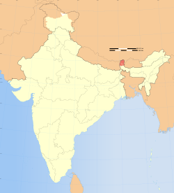
Location of Sikkim (marked in red) in India

Map of Sikkim
Lok Sabha 1
English
Sikkimese, and Lepcha (since 1977)
Limbu (since 1981)
Newari, Gurung, Magar, Sherpa, and Tamang (since 1995)
Sunwar (since 1996)
| Sikkim Nepali सिक्किम Sikkimese: སུ་ཁྱིམ་ |
||
|---|---|---|
| State | ||
|
||
 Location of Sikkim (marked in red) in India |
||
 Map of Sikkim |
||
| Coordinates (Gangtok): 27°20′N 88°37′E / 27.33°N 88.62°ECoordinates: 27°20′N 88°37′E / 27.33°N 88.62°E | ||
| Country | India | |
| Admission to Union † | 15 May 1975 | |
| Capital | Gangtok | |
| Largest city | Gangtok | |
| Districts | 4 | |
| Government | ||
| • Governor | Shriniwas Dadasaheb Patil | |
| • Chief Minister | Pawan Chamling (SDF) | |
| • Legislature | Unicameral (32 seats) | |
| • Parliamentary constituency | Rajya Sabha 1 Lok Sabha 1 |
|
| • High Court | Sikkim High Court | |
| Area | ||
| • Total | 7,096 km2 (2,740 sq mi) | |
| Area rank | 27th | |
| Population (2011)[1] | ||
| • Total | 610,577 | |
| • Rank | 28th | |
| • Density | 86/km2 (220/sq mi) | |
| Time zone | IST (UTC+05:30) | |
| ISO 3166 code | IN-SK | |
| HDI | ||
| HDI rank | 7th (2005) | |
| Literacy | 82.2% (13th) | |
| Official languages | Nepali (lingua franca) English Sikkimese, and Lepcha (since 1977) Limbu (since 1981) Newari, Gurung, Magar, Sherpa, and Tamang (since 1995) Sunwar (since 1996) |
|
| Website | sikkim.gov.in | |
| † Assembly of Sikkim abolished monarchy and resolved to be a constituent unit of India. A referendum was held on these issues and majority of the voters voted yes. On May 15, 1975 the President of India ratified a constitutional amendment that made Sikkim the 22nd state of India. | ||
Sikkim (/ˈsɪkɨm/; also known as Shikim or Su Khyim; see Toponymy for other names) is a landlocked Indian state located in the Himalayan mountains. The state is bordered by Nepal to the west, China's Tibet Autonomous Region to the north and east, and Bhutan to the east. The Indian state of West Bengal lies to the south.[2]
With 610,577 inhabitants as of the 2011 census,[1] Sikkim is the least populous state in India and the second-smallest state after Goa in total area, covering approximately 7,096 km2 (2,740 sq mi).[3] Sikkim is nonetheless geographically diverse due to its location in the Himalayas; the climate ranges from subtropical to high alpine, and Kangchenjunga, the world's third-highest peak, is located on Sikkim's border with Nepal.[4] Sikkim is a popular tourist destination, owing to its culture, scenery and biodiversity. It also has the only open land border between India and China.[5] Sikkim's capital and largest city is Gangtok.
According to legend, the Buddhist guru Padmasambhava visited Sikkim in the 8th century AD, introduced Buddhism and foretold the era of the Sikkimese monarchy.[6] Sikkim's Namgyal dynasty was established in 1642. Over the next 150 years, the kingdom witnessed frequent raids and territorial losses to Nepalese invaders.[citation needed] In the 19th century, it allied itself with British India, eventually becoming a British protectorate.[citation needed] In 1975, a referendum abolished the Sikkimese monarchy, and the territory was merged with India.[7]
Sikkim has 11 official languages: Nepali (which is its lingua franca), Sikkimese, Lepcha, Tamang, Limbu, Newari, Rai, Gurung, Magar, Sunwar and English.[8][9] English is taught in schools and used in government documents. The predominant religions are Hinduism and Vajrayana Buddhism. Sikkim's economy is largely dependent on agriculture and tourism, and as of 2012[update] the state has the third-smallest GDP among Indian states,[10] although it is also among the fastest-growing.[10][11]