झारखण्ड
جھارکھنڈ
 Seal |

Location of Jharkhand (marked in red) in India

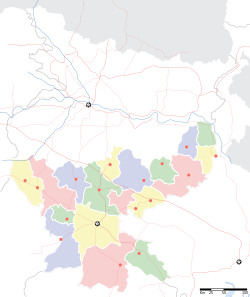
Map of Jharkhand
| Jharkhand झारखण्ड جھارکھنڈ |
||
|---|---|---|
| State of India | ||
|
||
 Location of Jharkhand (marked in red) in India |
||
 Map of Jharkhand |
||
| Coordinates (Ranchi): 23°21′N 85°20′E / 23.35°N 85.33°ECoordinates: 23°21′N 85°20′E / 23.35°N 85.33°E | ||
| Country | India | |
| Region | East India | |
| Established | 15 November 2000 | |
| Capital | Ranchi | |
| Largest city | Jamshedpur | |
| Government | ||
| • Governor | Syed Ahmed | |
| • Chief Minister | Hemant Soren (JMM) | |
| • Legislature | Unicameral (81 seats) | |
| • Parliamentary constituency | 14 | |
| • High Court | Jharkhand High Court | |
| Area | ||
| • Total | 79,714 km2 (30,778 sq mi) | |
| Area rank | 15th | |
| Population (2011) | ||
| • Total | 32,988,134 | |
| • Rank | 13th | |
| • Density | 414/km2 (1,070/sq mi) | |
| Time zone | IST (UTC+05:30) | |
| ISO 3166 code | IN-JH | |
| HDI | ||
| HDI rank | 24th (2005) | |
| Literacy | 67.6% (25th) | |
| Official Language[1] | Hindi | |
| Website | http://www.jharkhand.gov.in/ | |
Jharkhand (Jhārkhaṇḍ, pronounced [ˈdʒʱaːrkʰəɳɖ] (![]() ); Hindi: झारखंड) is a state in eastern India. It was carved out of the southern part of Bihar on 15 November 2000.[2] Jharkhand shares its border with the states of Bihar to the north, Uttar Pradesh and Chhattisgarh to the west, Odisha to the south, and West Bengal to the east. It has an area of 79,710 km2 (30,778 sq mi).
); Hindi: झारखंड) is a state in eastern India. It was carved out of the southern part of Bihar on 15 November 2000.[2] Jharkhand shares its border with the states of Bihar to the north, Uttar Pradesh and Chhattisgarh to the west, Odisha to the south, and West Bengal to the east. It has an area of 79,710 km2 (30,778 sq mi).
The industrial city, Ranchi, is its capital and Dumka is sub capital, Jamshedpur is the largest and the biggest industrial city of the state, while Dhanbad and Bokaro Steel City is the second & fourth most populous city.
The name "Jharkhand" means "The Land of Forests".[3] Jharkhand accounts for 40% of the mineral resources of India.