Assam
অসম |
| State of India |

Montage of Assam
Clockwise from top left: academic complex of IIT Guwahati, Ahom Raja's Palace (Garhgaon), Kamakhya temple (Guwahati), Rang Ghar pavilions (Sivasagar), Kolia Bhomora bridge over Brahmaputra river (Tezpur), one horned rhinoceros (Rhinoceros unicornis) at Kaziranga National Park, and Sivadol (Sivasagar). |
|
|
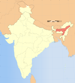
Location of Assam (marked in red) in India |
| Coordinates (Dispur): 26°08′N 91°46′E / 26.14°N 91.77°E / 26.14; 91.77Coordinates: 26°08′N 91°46′E / 26.14°N 91.77°E / 26.14; 91.77 |
| Country |
 India India |
| Region |
Northeast India |
| Established |
1912 (Assam Province - British India), 15 August 1947; 67 years ago (1947-08-15) (Assam - Independent India) |
| Capital |
Dispur |
Largest city
Largest metro |
Guwahati |
| Districts |
27 |
| Government |
| • Governor |
Janaki Ballabh Patnaik |
| • Chief Minister |
Tarun Gogoi (INC) |
| • Legislature |
Unicameral (126 seats) |
| • Parliamentary constituency |
14 |
| • High Court |
Gauhati High Court |
| Area |
| • Total |
79,000 km2 (31,000 sq mi) |
| Area rank |
16th |
| Population (2011) |
| • Total |
31,169,272 |
| • Rank |
14th |
| • Density |
390/km2 (1,000/sq mi) |
| Time zone |
IST (UTC+06:30) |
| ISO 3166 code |
IN-AS |
| HDI |
 0.534 (medium) 0.534 (medium) |
| HDI rank |
22nd (2005) |
| Literacy |
73.18% (26th)[1] |
| Official language |
Assamese |
| Co-official languages |
English,
Bengali (In the three districts of Barak Valley),
Bodo (In the four districts of Bodoland Territorial Council) |
| Website |
assam.gov.in |
|
^[*] Assam has had a legislature since 1937 ^[*] Assam is one of the original provinces of British India
|
| Symbols of Assam |
| Language |
Assamese |
| Song |
O Mur Apunar Dex |
| Dance |
Bihu dance |
| Animal |
One-horned rhinoceros |
| Bird |
White-winged Wood Duck |
| Flower |
Foxtail Orchids |
| Tree |
Dipterocarpus macrocarpus |
| River |
Brahmaputra |
Assam (//,  pronunciation (help·info); Ôxôm, [ɔxɔm]) is a state of India in the north-eastern region. Located south of the eastern Himalayas, Assam comprises the Brahmaputra Valley and the Barak river valleys along with the Karbi Anglong and the North Cachar Hills with an area of 30,285 square miles (78,438 km²). Assam is surrounded by six of the other Seven Sister States: Arunachal Pradesh, Nagaland, Manipur, Mizoram, Tripura, and Meghalaya. Geographically Assam and these states are connected to the rest of India via a strip of land in West Bengal called the Siliguri Corridor or "Chicken's Neck".[2] Assam shares international borders with Bhutan, Myanmar and Bangladesh; and cultures, peoples and climate with South-East Asia – elements in India’s Look East policy.[3] Assam became a part of British India after the British occupied the region following the First Anglo-Burmese War of 1824–1826.
Assam tea is produced here along with petroleum and Assam silk. The state has conserved the one-horned Indian rhinoceros from near extinction, along with the Pygmy hog, tiger and various species of birds. It provides one of the last wild habitats for the Asian elephant. The economy is aided by wildlife tourism while the Kaziranga and the Manas National Parks are designated as World Heritage Sites. Sal tree forests are found in the state, which as a result of rainfall looks green all year round. This rain feeds the Brahmaputra River, whose tributaries and oxbow lakes provide the region with a hydro-geomorphic and aesthetic environment.


